
The most recent satellite imagery from Google Maps offers a stark and unfiltered view of the destruction Gaza has endured since the outbreak of armed conflict in October 2023. Stadiums turned into makeshift camps, demolished hospitals, vanished schools, and entire neighborhoods reduced to rubble reveal the magnitude of the damage.
A City Disfigured by War, Seen Through Google Maps

The early hours of October 7, 2023, marked the beginning of the current conflict. Hamas militants crossed the border from Gaza into Israeli territory, launching attacks on residential areas and a music festival that left more than 1,200 people dead and 251 kidnapped. Israel’s military response was swift. Since then, Gaza has been subjected to a relentless military offensive.
As operations intensified, the Palestinian enclave’s infrastructure began to collapse. Entire neighborhoods vanished. According to the Gaza Ministry of Health, over 50,000 people had died from the conflict by March 2025. More recent estimates, published by the London School of Hygiene & Tropical Medicine (LSHTM) in The Lancet, suggest that between October 7, 2023, and June 30, 2024, at least 64,260 deaths were caused by traumatic injuries.

The majority of victims, according to UN data, were women and children. While the death toll alone is horrifying, the latest Google Maps images reveal the physical face of this catastrophe: hospitals razed to the ground, historic buildings wiped off the map, recreational areas rendered unrecognizable, and schools completely destroyed. What were once densely populated urban zones now appear as gray patches of dust and concrete.
The contrast between past and present satellite images clearly illustrates Gaza’s transformation into a ghost city. In a territory cut off by air, land, and sea, with limited resources, reconstruction remains a distant hope.
Satellite Imagery That Speaks for Itself

La importancia de la actualización de imágenes por parte de Google Maps va más allá del registro visual. Se convierte en una herramienta para la documentación de daños y una ventana para que el mundo vea lo que sucede sobre el terreno. En las fotos se aprecian cambios drásticos: avenidas antes llenas de tránsito, hoy desaparecidas; instalaciones médicas reconocidas, ahora convertidas en ruinas; parques convertidos en refugios improvisados.
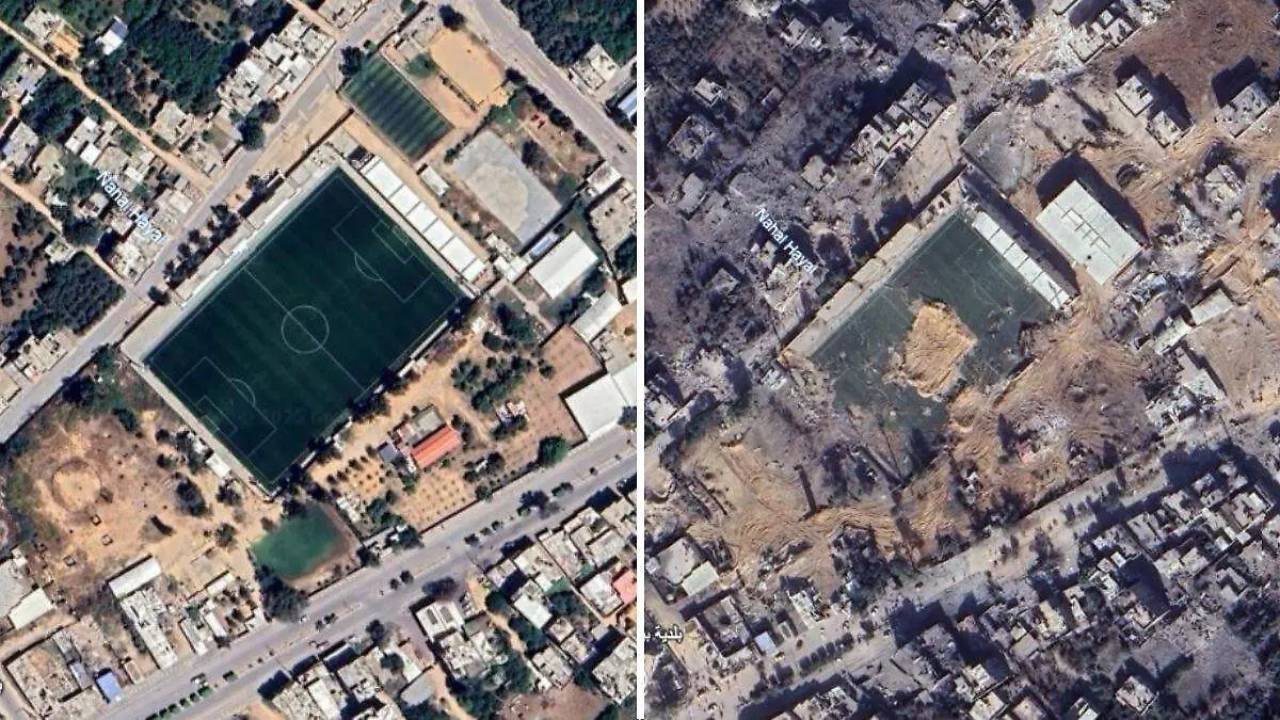
De lo que se puede ver en Google Maps, los estadios, por ejemplo, fueron adaptados como campamentos para miles de personas desplazadas internamente. Algunos centros deportivos, diseñados para albergar eventos comunitarios, ahora son hogares temporales para quienes perdieron todo.
Uno de los aspectos más alarmantes es la destrucción del sistema de salud. La infraestructura hospitalaria colapsó en gran parte del territorio, lo que pone en riesgo a los sobrevivientes que ahora enfrentan condiciones sanitarias extremas, falta de atención médica y acceso limitado a medicamentos. Esto representa un desastre de salud pública en medio de una crisis humanitaria sin precedentes en la región.
Según informes recientes, al menos 70 % de las instalaciones médicas han sido dañadas o destruidas. La situación complica aún más la atención a los heridos y enfermos en un entorno ya de por sí colapsado.
Además, la devastación ha provocado el desplazamiento forzoso de más de dos millones de personas dentro del propio territorio palestino, según datos de la ONU. La Franja de Gaza, uno de los lugares más densamente poblados del mundo, ha visto cómo su población es forzada a migrar continuamente, con escasos recursos, bajo constantes ataques y sin un lugar seguro al que huir.
Mientras tanto, los llamados internacionales para un alto el fuego permanente continúan, pero las negociaciones siguen estancadas y el sufrimiento civil no cesa.
Una herramienta que denunGoogle Maps’ updated imagery serves a purpose beyond visual recordkeeping. It becomes a documentation tool and a window through which the world can witness the on-the-ground reality. The images reveal drastic changes: roads once bustling with traffic are now gone; formerly prominent medical facilities lie in ruins; parks have become improvised shelters.
From what can be seen in Google Maps, stadiums have been repurposed as camps for thousands of internally displaced people. Sports centers once intended for community events now function as temporary homes for those who have lost everything.
One of the most alarming aspects is the collapse of the healthcare system. Hospital infrastructure across much of the region has failed, putting survivors at risk of extreme sanitary conditions, lack of medical care, and limited access to medication. This has created a public health disaster amid an unprecedented humanitarian crisis in the region.
Recent reports indicate that at least 70% of medical facilities have been damaged or destroyed. This makes treating the injured and sick even more difficult in an already overwhelmed environment.
Furthermore, the destruction has led to the forced displacement of over two million people within Gaza itself, according to the UN. One of the most densely populated regions on Earth has seen its population driven into constant migration—under fire, with scarce resources, and nowhere safe to flee.
Meanwhile, international calls for a permanent ceasefire continue, but negotiations remain deadlocked, and civilian suffering persists.
A Tool That Speaks Outcia

Historically used for educational, touristic, or scientific purposes, Google Maps has taken on a new role in Gaza: that of a silent witness. Thanks to its updated satellite images, people around the world—journalists, citizens, and human rights organizations—can access visual evidence of the scale of the disaster.
These images don’t just show rubble. They allow us to track the systematic destruction of hospitals, universities, schools, and cultural centers. In many cases, these visuals may also serve as documentation in future investigations into potential war crimes.
The high-resolution imagery makes it possible to observe the gradual erasure of structures essential to civilian life. Water quality, electricity grids, sewage systems, and medical supply chains have been disrupted, creating a multidimensional crisis from which few have emerged unscathed.
Google Maps imagery also helps debunk denialist narratives and confront authorities with the reality on the ground. They serve as a counterbalance to the information blackout often surrounding armed conflicts—especially when media and international organizations are restricted from entering.
By showing the “before and after” of the Gaza Strip, these satellite images do more than highlight the destruction—they illuminate what has been lost: homes, history, culture, lives.
Reference:
- Google Maps Coordinates: Link
COMPARTE ESTE ARTICULO EN TUS REDES FAVORITAS:

Esta entrada también está disponible en:
![]() Español
Español
Discover more from Cerebro Digital
Subscribe to get the latest posts sent to your email.


